Most Amazing Outdoor Places To Visit On Valley Isle
Unspoiled rainforest, botanical parks, huge monolithic rocks – western Maui has a variety of spectacular natural attractions. Here are some of the highlights of the western Maui region:
West Maui Mountains – Summit of Puu Kukui
Some of the last untouched rainforest on Maui sits atop the summit of Puu Kukui, which means Hill of Light, and is one of the wettest spots on Earth and also the highest place on western Maui. The Puu Kukui private preserve, which is home to many rare native plants and birds, encompasses more than 8,000 acres. Only 12 people are allowed to visit this remote area each year, and the lucky few are chosen by a lottery system managed b the Kapalua Nature Society.
Iao Valley State Park / Kepaniwai Park
The towering spire of basalt known as the Iao Needle stands tall within Iao Valley State Park, a burial place of ancient chiefs and also as the site of a famous 1790 battle of the rising warrior who would become King Kamehameha the Great. Kamehameha was victorious in this battle which resulted in so many warriors killed that their bodies were said to have blocked the river, giving the battle its name, the Battle of Kepaniwai, which means The Water Dam.
Kepaniwai Park and Heritage Gardens
Also within the Iao Valley State Park is Kepaniwai Park and Heritage Gardens, featuring cultural exhibits, pavilions, and horticulture. Ethnic displays and traditional dwellings in the park are memorials to the many immigrant cultures that originally came to Hawaii to work on the sugarcane plantations. The Iao Valley Trail is a nice family-friendly trail that features many lovely pools. After you walk up some steps at the top of the Iao Valley Trail you will have a fantastic view of the 1200-foot Iao Needle, also known by its Hawaiian name, Kukaemoku.
Hawai‘i Nature Center
Located in Iao Valley, the Hawaii Nature Center is fun for kids and adults alike, providing many hands-on exhibits at an Interatctive Nature Museum that help you learn about the area flora, fauna, and Hawaiian culture.
Puuolai and La Perouse Bay
The red cinder cone of Puuolai rises to more than 360 feet aking it quite noticeable when you visit La Perouse Bay. The cinder cone of Puuolai formed about 200 years ago during an eruption of Haleakala Volcano. Many Hawaiians lived in this area in ancient times. The cinder cone of Puuolai stands between Big Beach (Oneloa) and Little Beach.
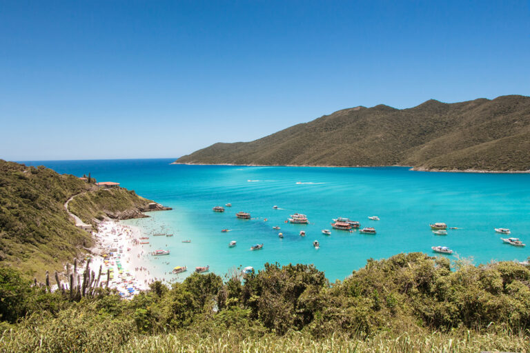
Molokini Crater
Located between the islands of Kahoolawe and Maui about three miles from Makena on Maui), the sunken crescent-shaped volcanic crater is now a marine conservation area teeming with colorful, tropical fish. The crater walls rise to 165 feet above sea level enclosing one of Hawaii’s best snorkeling areas.
Kahoolawe
This relatively dry island just south of Maui has a long history of military use for target practice. The bombing of the island stopped in 1990, and Kahoolawe was returned to the State of Hawaii in 1993. Kahoolawe is now being restored and reclaimed by native Hawaiian groups for cultural purposes. Kaho‘olawe is about 6 miles wide and 11 miles long, and according to tradition is the sacred home of the god Kanaloa. Many heiau, sacred places of Hawaiian worship, have been identified on Kahoolawe attesting to its importance to Hawaiians in ancient times. The Kahoolawe mountain called Moaulaiki was used by Hawaiians as a place to train ocean navigators in the arts of celestial navigation. Even though many areas of Kahoolawe were destroyed by military bombing, more than 500 archaeological sites have been identified as well as about 3,000 archaeological features. The westernmost point of Kahoolawe is a rock outcropping known as Kealaikahiki, which was also an important site for the training of ocean navigators of ancient Hawaii.
Haleakala National Park
The dormant Haleakala Volcano rises to 10,023 feet and is a favorite place to view the sunrise and to gaze over the ocean and see the other Hawaiian Islands. The trail that descends down into Haleakala’s massive summit crater is a great hike across a landscape similar to the moon. You can also take a tour on horseback with Pony Express Tours (808-667-2200). Haleakala National Park (808-572-4400, 871-5054) is home to many native plants and wildlife. Much of this diversity of landscapes and native life forms can be seen on the Kaupo Trail that descends from the summit all the way to the coast at Kipahulu. The volcano is also very important in Hawaiian culture, and said to be where the demigod Maui lassoed the rays of the sun to make it move more slowly. He did this so his mother Hina had time to dry her tapa barkcloth. Astronomy installations atop Haleakala’s summit include the Maui Space Surveillance Site, the Advanced Electro-Optical System 3.7-meter Telescope, the Lunar Ranging Facility, and the Mees Solar Observatory.
Haleakala’s Summit Crater
The crater atop Haleakala is 3,000 feet deep and 7 miles long. The Haleakala summit area was important in ancient Hawaiian astronomy, and where the Hawaiian astronomers mapped the massive summit crater that served as a sundial and a place to map out the heavens. Streaked with lava and cinder flows, the crater also features huge cinder cones up to 600 feet tall. A unique phenomenon known to occur atop Haleakala is known as akaku anuenue (rainbow apparition), also known as the “Specter of the Brocken.” This occurs when a person at an overlook sees their own shadow on the clouds below completely encircled by a rainbow.
Polipoli Spring State Recreation Area
Located on the western slopes of Haleakala Volcano in the Kula Forest Reserve at an elevation around 6,000 feet above sea level, Polipoli State Park (808-984-8109) features an impressive redwood forest along with other coniferous forests including sequoias and pine trees as well as cedar, cypress, eucalyptus, and ash trees. Many hiking trails in the park provide enjoyable upcountry adventures. The Redwood Trail is about 2 miles long and starts at an elevation of 6,200 feet wihin the Park. Other trails in the park include the Plum Trail and the Haleakala Ridge Trail.
Keanae Arboretum and Wailua
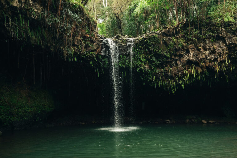
This wonderland of plants is located along the road to “heavenly Hana” at Mile Marker 17 on Maui’s eastern side. One area features plants that were brought by the first Polynesian settlers of the islands to use for food including bananas, breadfruit, taro, and more. The Piinaau Stream here has a nice swimming hole to enjoy, and you can hike to a nice forested area alongside a taro patch. At Mile Marker 21 the Wailua Overlook has great views of Wailua Canyon and the village there that includes the historic church known as Our Lady of Fatima Shrine which was built in 1860 using coral. Just past Mile Marker 21 is the spectacular Waikane Falls.
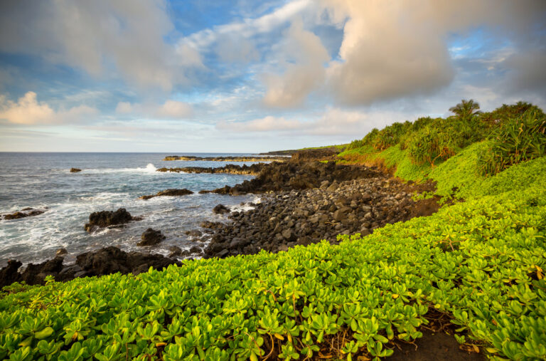
Waianapanapa
Located at Mile Marker 32 just before you reach the town of Hana in eastern Maui, Waianapanapa State Park (808-984-8109) is a black sand beach lined with lava arches and caves. Atop the bluff is a wonderful grassy area where you can relax and enjoy the beautiful views. A beach trail here leads you along the coast to view the black lava spires, tidepools, and freswater pools as well as important archaeological sites amidst the black sand beaches. Camping at Waianapanapa is allowed with a permit.